FeatureFilter
require(["esri/views/layers/support/FeatureFilter"], function(FeatureFilter) { /* code goes here */ });esri/views/layers/support/FeatureFilterThis class defines parameters for setting a client-side filter on a layer view. Once a FeatureFilter object's properties are defined, it can be used to set the filter property of the layer view.
You can set filters by attributes, time, geometry and geometry with distance. Only the features that meet the requirements specified in the filter will be displayed. Filters only affect feature visibility. They do not return geometry or attribute information associated with the filtered features. The queryFeatures method must be called to access additional information.
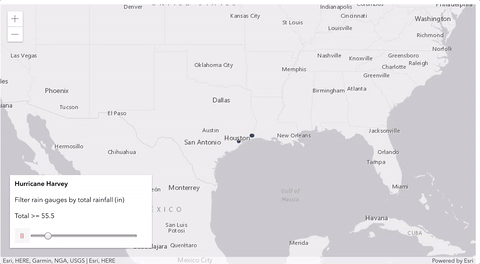
// display rain gauges where their water percent is over 30%
// and if the gauges are completely contained by the 10-mile
// buffer around the filter geometry
featureLayerView.filter = new FeatureFilter({
  where: "percentile >= 30",
  geometry: filterPolygon,
  spatialRelationship: "contains",
  distance: 10,
  units: "miles"
});
- See also:
Constructors
- new FeatureFilter(properties)
- Parameter:properties Objectoptional
See the properties for a list of all the properties that may be passed into the constructor.
Example:// Typical usage const filter = new FeatureFilter({ where: "magnitude >= 3" }); layerView.filter = filter;
Property Overview
| Name | Type | Summary | Class | |
|---|---|---|---|---|
| String | The name of the class. more details | more details | Accessor | |
| Number | Specifies a search distance from a given geometry in a spatial filter. more details | more details | FeatureFilter | |
| Geometry | The geometry to apply to the spatial filter. more details | more details | FeatureFilter | |
| Number[] | An array of objectIds of the features to be filtered. more details | more details | FeatureFilter | |
| String | For spatial filters, this parameter defines the spatial relationship to filter features in the layer view against the filter geometry. more details | more details | FeatureFilter | |
| TimeExtent | A range of time with start and end date. more details | more details | FeatureFilter | |
| String | The unit for calculating the buffer distance when distance is specified in a spatial filter. more details | more details | FeatureFilter | |
| String | A where clause for the feature filter. more details | more details | FeatureFilter |
Property Details
The name of the class. The declared class name is formatted as
esri.folder.className.
- distance Number
Specifies a search distance from a given geometry in a spatial filter. The units property indicates the unit of measurement. In essence, setting this property creates a buffer at the specified size around the input geometry. The filter will use that buffer to display features in the layer or layer view that adhere to the to the indicated spatial relationship.
The geometry to apply to the spatial filter. The spatial relationship as specified by spatialRelationship will indicate how the geometry should be used to filter features.
Known Limitations
Mesh geometry types are currently not supported.
An array of objectIds of the features to be filtered.
- spatialRelationship String
For spatial filters, this parameter defines the spatial relationship to filter features in the layer view against the filter geometry. The spatial relationships discover how features are spatially related to each other. For example, you may want to know if a polygon representing a county completely contains points representing settlements.
The spatial relationship is determined by whether the boundaries or interiors of a geometry intersect.
- Boundary — The endpoints of all linear parts for line features, or the linear outline of a polygon. Only lines and polygons have boundaries.
- Interior — Points are entirely interior and have no boundary. For lines and polygons, the interior is any part of the geometry that is not part of the boundary.
The possible values for this parameter are described below and the images highlight the geometries returned for the specified spatial relationship for given geometries.
The
intersectsspatial relationship returns features in the layer view that intersect the filter geometry.Known Limitations
The filter of SceneLayerView with 3D object scene layers only supports the spatial relationships
contains,intersectsanddisjoint.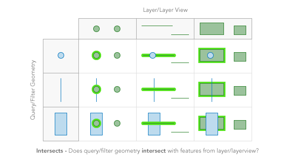
The
containsspatial relationship returns features in the layer view that are completely contained by the filter geometry.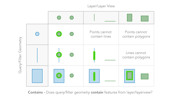
The
crossesspatial relationship returns features in the layer view when the interior of a filter geometry comes into contact with the interior or boundary of features in the layer view. In other words, the geometries share some interior area, but not all interior area.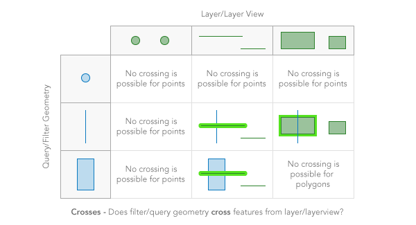
The
envelope-intersectsspatial relationship returns features in the layer view that intersect the envelope (or extent) of the filter geometry.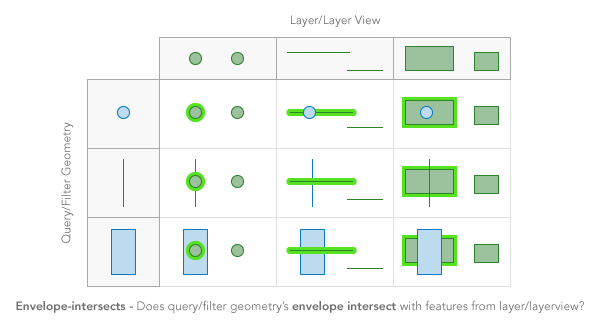
The
overlapsspatial relationship returns features in the layer view that overlap the filter geometry. Only features of the same geometry can be compared.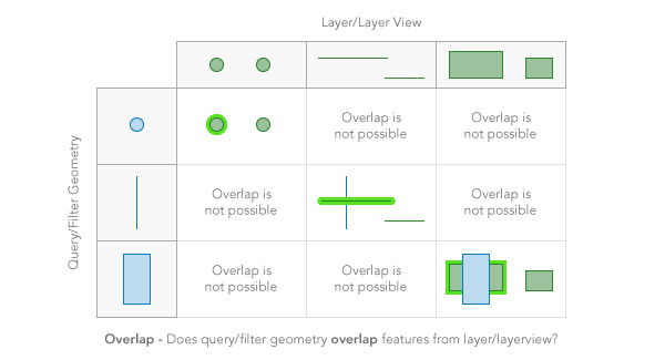
The
touchesspatial relationship returns features in the layer view that touch the filter geometry. The boundaries of the geometries intersect, but not their interiors.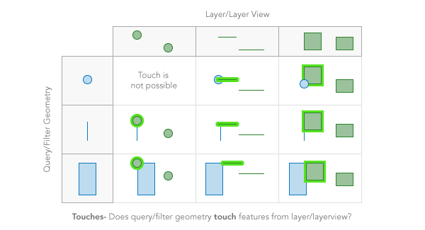
The
withinspatial relationship returns features in the layer view that completely contain the filter geometry. In other words, the filter geometry is completelywithinthe features in the layer view. It is opposite ofcontains.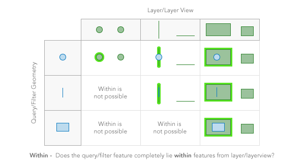
The
disjointspatial relationship returns features in the layer view that do not intersect the filter geometry in anyway. Opposite ofintersects.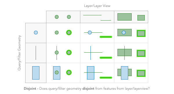
- Default Value:intersects
- See also:
Example:// display features that are completely within state var filter = new FeatureFilter({ spatialRelationship: "contains", geometry: statePolygon });
- timeExtent TimeExtent
A range of time with start and end date. Only the features that fall within this time extent will be displayed. The Date field to be used for
timeExtentshould be added to outFields list when the layer is initialized. This ensures the best user experience when switching or updating fields for time filters.- Default Value:null
- units String
The unit for calculating the buffer distance when distance is specified in a spatial filter. If
unitsis not specified, the unit is derived from the filter geometry's spatial reference.Possible Values:"feet"|"miles"|"nautical-miles"|"us-nautical-miles"|"meters"|"kilometers"
- Default Value:null
- where String
A where clause for the feature filter. Any legal SQL92 where clause operating on the fields in the layer is allowed. Be sure to have the correct sequence of single and double quotes when writing the where clause in JavaScript.
For apps where users can interactively change fields used for attribute filter, we suggest you include all possible fields in the outFields of the layer. This ensures the best user experience when switching or updating fields for attribute filters.
Examples:filter.where = "NAME = '" + stateName + "'";filter.where = "POP04 > " + population;
Method Overview
| Name | Return Type | Summary | Class | |
|---|---|---|---|---|
| FeatureFilter | Creates a deep clone of FeatureFilter object. more details | more details | FeatureFilter | |
| Query | Creates query parameters that can be used to fetch features that satisfy the layer's current filters and definitions. more details | more details | FeatureFilter | |
| * | Creates a new instance of this class and initializes it with values from a JSON object generated from a product in the ArcGIS platform. more details | more details | FeatureFilter | |
| Object | Converts an instance of this class to its ArcGIS portal JSON representation. more details | more details | FeatureFilter |
Method Details
- clone(){FeatureFilter}
Creates a deep clone of FeatureFilter object.
Returns:Type Description FeatureFilter A new instance of a FeatureFilter object equal to the object used to call .clone().
- createQuery(){Query}Since: ArcGIS API for JavaScript 4.12
Creates query parameters that can be used to fetch features that satisfy the layer's current filters and definitions.
Returns:Type Description Query The query object representing the layer's filters and other definitions. Example:// Get a query object from the filter's current configuration const queryParams = layerView.filter.createQuery(); // set a geometry for querying features by the view's extent queryParams.geometry = view.extent; // query the layer with the modified params object layerView.queryFeatures(queryParams) .then(function(results){ // prints the array of result graphics to the console console.log(results.features); });
- fromJSON(json){*}static
Creates a new instance of this class and initializes it with values from a JSON object generated from a product in the ArcGIS platform. The object passed into the input
jsonparameter often comes from a response to a query operation in the REST API or a toJSON() method from another ArcGIS product. See the Using fromJSON() topic in the Guide for details and examples of when and how to use this function.Parameter:json ObjectA JSON representation of the instance in the ArcGIS format. See the ArcGIS REST API documentation for examples of the structure of various input JSON objects.
Returns:Type Description * Returns a new instance of this class.
- toJSON(){Object}
Converts an instance of this class to its ArcGIS portal JSON representation. See the Using fromJSON() topic in the Guide for more information.
Returns:Type Description Object The ArcGIS portal JSON representation of an instance of this class.