WaterSymbol3DLayer
require(["esri/symbols/WaterSymbol3DLayer"], function(WaterSymbol3DLayer) { /* code goes here */ });esri/symbols/WaterSymbol3DLayerWaterSymbol3DLayer is used to render Polygon geometries as realistic, animated water surfaces, therefore it can only be used inside a PolygonSymbol3D.
Various properties can be set to enhance the realistic effect of this symbol layer. The waveStrength can be set to show the magnitude of the waves and waveDirection indicates the direction in which the waves travel. The waterbodySize can be set to specify how large the waterbody is. The dominant color of the water can be used to change the appearance of the water.
This symbol layer is not supported in a MapView.
Autocasting support
As of version 4.5 of the ArcGIS API for JavaScript, autocasting is universally supported for all renderers, symbols, and symbol layers in the API. So there is no need to include this module in the require() and define() module loaders of your application unless you intend to use the static method(s) of this module.
- See also:
const waterLayer = new FeatureLayer({
  ...,
  renderer: {
    type: "simple",
    symbol: {
      type: "polygon-3d",
      symbolLayers: [{
        type: "water",
        waveDirection: 180,
        color: "#5975a3",
        waveStrength: "moderate",
        waterbodySize: "small"
      }]
    }
  }
});
Constructors
- new WaterSymbol3DLayer(properties)
- Parameter:properties Objectoptional
See the properties for a list of all the properties that may be passed into the constructor.
Property Overview
| Name | Type | Summary | Class | |
|---|---|---|---|---|
| Color | The dominant color used to shade the water. more details | more details | WaterSymbol3DLayer | |
| String | The name of the class. more details | more details | Accessor | |
| String | The symbol type. more details | more details | WaterSymbol3DLayer | |
| String | Indicates the size of the waterbody which is represented by the symbol layer. more details | more details | WaterSymbol3DLayer | |
| Number | Indicates the direction in which the waves travel. more details | more details | WaterSymbol3DLayer | |
| String | Indicates the shape and intensity of the waves. more details | more details | WaterSymbol3DLayer |
Property Details
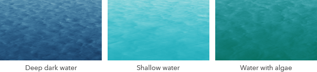
- color Color
The dominant color used to shade the water. The water has different shades of the dominant color based on the reflection of the light. The image below shows how different types of water can be represented with different colors. For example for deep water the dominant color could be navy blue.
The color can be autocast with an array of rgb(a) values, named string, hex string or an hsl(a) string, an object with
r,g,b, andaproperties, or a Color object.- Default Value:#0077BE
Example:// a new color by a HEX string symbolLayer.color = "#005B66";
The name of the class. The declared class name is formatted as
esri.folder.className.
- type Stringreadonly
The symbol type.
For WaterSymbol3DLayer the type is always "water".
- waterbodySize String
Indicates the size of the waterbody which is represented by the symbol layer.
smallcan be set for small lakes, rivers or swimming pools,mediumcan be set for large lakes, whereaslargeis recommended for ocean and sea waterbodies.Possible Values:"small"|"medium"|"large"
- Default Value:medium
Example:// sets the waterBodySize for an ocean like waterbody. symbolLayer.waterbodySize = "large";
- waveDirection Number
Indicates the direction in which the waves travel. This value represents the geographic rotation in degrees and it ranges from 0 to 360 degrees. A value of 0 degrees corresponds to geographic north, which means that the wave travels from south to north.
The default is set to
null, which will display the waves without a distinct direction.- Default Value:null
Example:// sets the wave direction to 215 degrees symbolLayer.waveDirection = 215;
- waveStrength String
Indicates the shape and intensity of the waves. Currently only calm to moderate waterbodies can be represented. A
calmwave strength represents water without waves, acting almost like a mirror. A water withrippledwave strength has very small and short waves.slightwave strength displays the waves with a more pronounced form, but they are still quite short. Choosingmoderatewill display waves with a longer form and a slightly increased intensity.Possible Values:"calm"|"rippled"|"slight"|"moderate"
- Default Value:moderate
Example:// sets the wave strength to small waves symbolLayer.waveStrength = "slight";
Method Overview
| Name | Return Type | Summary | Class | |
|---|---|---|---|---|
| WaterSymbol3DLayer | Creates a deep clone of the symbol layer. more details | more details | WaterSymbol3DLayer | |
| * | Creates a new instance of this class and initializes it with values from a JSON object generated from a product in the ArcGIS platform. more details | more details | Symbol3DLayer | |
| Object | Converts an instance of this class to its ArcGIS portal JSON representation. more details | more details | Symbol3DLayer |
Method Details
- clone(){WaterSymbol3DLayer}
Creates a deep clone of the symbol layer.
Returns:Type Description WaterSymbol3DLayer A deep clone of the object that invoked this method. Example:// Creates a deep clone of the graphic's first symbol layer var symLyr = graphic.symbol.symbolLayers.getItemAt(0).clone();
- fromJSON(json){*}static
Creates a new instance of this class and initializes it with values from a JSON object generated from a product in the ArcGIS platform. The object passed into the input
jsonparameter often comes from a response to a query operation in the REST API or a toJSON() method from another ArcGIS product. See the Using fromJSON() topic in the Guide for details and examples of when and how to use this function.Parameter:json ObjectA JSON representation of the instance in the ArcGIS format. See the ArcGIS REST API documentation for examples of the structure of various input JSON objects.
Returns:Type Description * Returns a new instance of this class.
Converts an instance of this class to its ArcGIS portal JSON representation. See the Using fromJSON() topic in the Guide for more information.
Returns:Type Description Object The ArcGIS portal JSON representation of an instance of this class.