SceneView
require(["esri/views/SceneView"], function(SceneView) { /* code goes here */ });esri/views/SceneView- Overview
- Using the view
- SceneView navigation
- SceneView navigation with gamepad and 3DConnexion devices
- Programmatic navigation
- Viewing modes
- Supported Coordinate Systems
- Using elevation data
Overview
A SceneView displays a 3D view of a Map or WebScene instance using WebGL. To render a map and its layers in 2D, see the documentation for MapView. For a general overview of views, see View.

For a map to be visible to the user in the DOM, a SceneView must have both a valid Map instance and a DOM element with a non-zero height and width in which to render. Note that there must be valid data in the map, such as operational layers or a basemap with base layers, before the view will begin rendering the map.
// Create a basic SceneView instance with a basemap and world elevation
var view = new SceneView({
  // An instance of Map or WebScene
  map: new Map({
    basemap: "hybrid"
  }),

  // The id of a DOM element (may also be an actual DOM element)
  container: "viewDiv"
});
Known Limitations
The number of features that can be rendered in a SceneView varies depending on the complexity of each feature's geometry and symbol. Layers with a large number of features are dynamically loaded and displayed as you navigate the scene. For optimal performance, the number of displayed features is adjusted based on the complexity of the symbol and device capability. As a result, some features may not be visible in the view.
SceneView does not support rendering of Multipoint geometry.
Read more
Using the view
A SceneView may not be immediately ready for display after it has been constructed. For example, map data may need to be loaded first to determine the spatialReference of the view, or the DOM container may not yet have a non-zero size. Many of the view methods (such as hitTest or goTo) need the view to be ready before they can be used.
// create a SceneView instance (for 3D viewing)
var view = new SceneView({
  map: new Map({
    basemap: "topo"
  }),

  container: "viewDiv"
});


view.when(function() {
      // SceneView is now ready for display and can be used. Here we will
      // use goTo to view a particular location at a given zoom level, camera
      // heading and tilt.
      view.goTo({
        center: [-112, 38],
        zoom: 13,
        heading: 30,
        tilt: 60
      })
    })
    .catch(function(err) {
      // A rejected view indicates a fatal error making it unable to display,
      // this usually means that WebGL is not available, or too old.
      console.error("SceneView rejected:", err);
    });
For live examples of view.when(), see the 2D overview map in SceneView and Toggle elevation layer samples.
SceneView navigation
The view can be navigated programmatically via goTo() and the view properties or interactively with mouse, keyboard or touch inputs. SceneView navigation is enabled by defaults, and includes the mouse, keyboard and touch interactions as described in the table below. Touch interactions are working on any touch enabled monitor or laptop screen.
| Action | SceneView behavior |
|---|---|
| Drag | Pan |
| Double-click | Zoom in at the cursor |
| Scroll forward | Zoom in at the cursor |
| Scroll backward | Zoom out at the center of the view |
| Right-click+Drag | 3D-rotate around the center of the view |
| Arrow Keys | Nudge the view left, right, up, or down (only supported in global scene) |
| B + Left-click+Drag | 3D-rotate around the camera's position |
| P | Move the camera to look perpendicular to the data displayed in the view |
| N | Adjust the SceneView to point north |
| W | Tilt camera up |
| A | Rotate camera counterclockwise |
| S | Tilt camera down |
| D | Rotate camera clockwise |
| J | Move down, closer to the view (only supported in global scene) |
| U | Move up, higher from the view (only supported in global scene) |
| Drag with one or multiple fingers | Pan |
| Double-tap with one finger | Zoom in at the finger position |
| Two finger pinch in/out | Zoom out/in |
| Move two fingers in clockwise or counterclockwise direction | Rotate |
| Drag two fingers up or down the screen | Tilt the scene |
To disable SceneView navigation, you must call the stopPropagation() method on the event objects of the pointer or gesture events that trigger the navigation.
See our samples on disabling view navigation for examples.
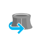
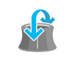
SceneView navigation with Gamepad and 3DConnexion devices
Gamepad and 3Dconnexion devices, like the SpaceMouse, can be used for navigation when view.navigation.gamepad.enabled is set to true(default). Please see GamepadInputDevice for supported devices.
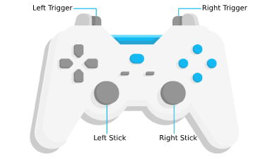
| Gamepad Action | SceneView behavior |
|---|---|
| Left Trigger | Descend |
| Right Trigger | Ascend |
| Left Stick | Pan |
| Right Stick | 3D-rotate around the center of the view |
| Action Image | SpaceMouse Action | SceneView behavior |
|---|---|---|
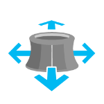 | Push (left/right/forward/backward) | Pan |
 | Pull up | Ascend |
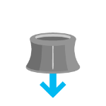 | Push down | Descend |
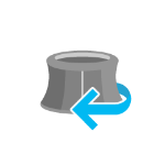 | Rotate clockwise | Rotate the view clockwise |
 | Rotate counterclockwise | Rotate the view counterclockwise |
 | Tilt | Tilt the scene |
To disable gamepad navigation, you can set view.navigation.gamepad.enabled to false.
Programmatic navigation
Traditional 2D mapping properties, such as scale, zoom, center and extent do not always work well in 3D. For example, a map's scale is not clear when viewed in the context of a globe. The SceneView therefore supports these properties on a best effort basis, with certain limitations (see the documentation of individual properties for more information).
// Compatibility with 2D viewing properties, such as center and zoom, allows
// convenient transitioning from the familiar use of the 2D MapView to the
// use of the SceneView for 3D viewing.
var view = new SceneView({
  map: new Map({
    basemap: "satellite"
  }),

  container: "viewDiv",

  // Sets the center point of the view at a specified lon/lat
  center: [-112, 38],

  // Sets the zoom LOD to 13
  zoom: 13
});
The nature of 3D viewing includes oblique views, z-values, and rotation, all of which add complexity to defining what is visible in the view. In contrast to 2D MapView, which are primarily defined by an extent, or center and scale, the primary view specification of the SceneView is a Camera instance. The camera is defined by a 3D position, heading and tilt. See the documentation of Camera for more details.
Because some view properties overlap (e.g. center and camera), there is a set priority in which these properties are applied during construction of the view (until the view becomes ready). The following table describes which properties have priority during view construction (properties that are overridden will have no effect during construction).
| Property | Overrides |
|---|---|
| camera | viewpoint, extent, center, scale, zoom |
| viewpoint | extent, center, scale, zoom |
| extent | center, scale, zoom |
| scale | zoom |
It can be difficult to define the camera for viewing data at a particular location. The goTo method provides a convenient way to set the view's camera based on data (geometries, graphics) you want to view and from any perspective using heading, tilt, scale or zoom. Additionally, goTo will provide a smooth transition to the new location of the view by default.
// go to a location specified in geographic coordinates,
// from a 45 degree angle.
view.goTo({
  center: [-112, 38],
  heading: 45
});

// go to view all the graphics in view.graphics, while northing the
// the camera and tilting it to 60 degrees
view.goTo({
  target: view.graphics,
  heading: 0,
  tilt: 60
});

// Set the view to show an extent at a -20 degree heading, disabling the
// animated transition
view.goTo({
  target: new Extent(694942, 5596444, 1284090, 6163926, SpatialReference.WebMercator),
  heading: -20
}, {
  animate: false
});
Viewing modes

The SceneView supports two different viewing modes, global (left picture above) and local (right picture above), specified by the viewingMode property. Global scenes render the earth as a globe, while local scenes render the surface on a flat plane. Local mode allows for navigation and feature display in a localized or clipped area. In both viewing modes the users may navigate the camera below the ground surface by setting the esri/Ground#navigationConstraint#type to none.
The viewing mode (if not explicitly set by the user) is determined based on the spatial reference of the view. If the spatial reference is either Web Mercator or WGS84, then the viewingMode will default to global. For any other spatial reference the viewingMode will default to local.
Supported coordinate systems
The SceneView supports following coordinate systems in a global scene:
- WGS84 or WebMercator
- Noncached layers with any spatial reference since they will be reprojected to the scene spatial reference
In a local scene the following coordinate systems are supported:
- Any Projected Coordinate System
- Noncached layers with any spatial reference since they will be reprojected to the scene spatial reference
Using elevation data
The SceneView will use elevation layers from the Map.ground as sources for elevation when rendering the ground surface. Similar to the basemap, the ground can be initialized with a well-known name, which creates it with a known set of elevation layers.
var view = new SceneView({
  map: new Map({
    basemap: "satellite",

    // A ground preset containing a single elevation layer, sourced from
    // https://elevation3d.arcgis.com/arcgis/rest/services/WorldElevation3D/Terrain3D/ImageServer
    ground: "world-elevation"
  },

  container: "viewDiv"
});
Local elevation layers can be added to the ground.layers to merge multiple elevation sources into a single surface. See 3D Map With Elevation Services for an example.
- See also:
Constructors
- new SceneView(properties)
- Parameter:properties Objectoptional
See the properties for a list of all the properties that may be passed into the constructor.
Example:// Typical usage var view = new SceneView({ // ID of DOM element containing the view container: "viewDiv", // Map/WebScene object map: new Map() });
Property Overview
| Name | Type | Summary | Class | |
|---|---|---|---|---|
| Collection<LayerView> | Collection containing a flat list of all the created LayerViews related to the basemap, operational layers, and group layers in this view. more details | more details | View | |
| Boolean | Allows the view to be partially or fully transparent when composited with the webpage elements behind it. more details | more details | SceneView | |
| ViewAnimation | Represents an ongoing view animation initialized by goTo(). more details | more details | View | |
| BasemapView | Represents the view for a single basemap after it has been added to the map. more details | more details | View | |
| Object | A convenience property used for defining the breakpoints on the height and width of the view. more details | more details | SceneView | |
| Camera | The observation point from which the visible portion (or perspective) of the SceneView is determined. more details | more details | SceneView | |
| Point | Represents the view's center point; when setting the center you may pass a Point instance or an array of numbers representing at longitude/latitude pair ( | more details | SceneView | |
| Extent | Represents an optional clipping area used to define the visible extent of a local scene. more details | more details | SceneView | |
| Accessor | Specifies constraints for Camera tilt and altitude that may be applied to the SceneView. more details | more details | SceneView | |
| HTMLDivElement | The | more details | View | |
| String | The name of the class. more details | more details | Accessor | |
| Accessor | Specifies various properties of the environment's visualization in the view. more details | more details | SceneView | |
| Extent | The extent represents the visible portion of a map within the view as an instance of Extent. more details | more details | SceneView | |
| Error | A fatal error returned when the view loses its WebGL context. more details | more details | View | |
| Boolean | Indicates if the browser focus is on the view. more details | more details | View | |
| Collection<Graphic> | Allows for adding graphics directly to the default graphics in the View. more details | more details | View | |
| GroundView | The view for the ground of the map. more details | more details | SceneView | |
| Number | The height of the view in pixels read from the view container element. more details | more details | View | |
| String | A convenience property indicating the general size of the view's height. more details | more details | SceneView | |
| Object | Options for configuring the highlight. more details | more details | SceneView | |
| Input | Options to configure input handling of the View. more details | more details | View | |
| Boolean | Indication whether the view is being interacted with (for example when panning). more details | more details | View | |
| Collection<LayerView> | A collection containing a hierarchical list of all the created LayerViews of the operational layers in the map. more details | more details | View | |
| Map | An instance of a Map object to display in the view. more details | more details | View | |
| Navigation | Options to configure the navigation behavior of the View. more details | more details | View | |
| String | A convenience property indicating the view's orientation. more details | more details | SceneView | |
| Object | Use the padding property to make the center, and extent, etc. more details | more details | View | |
| Popup | A Popup object that displays general content or attributes from layers in the map. more details | more details | View | |
| String | SceneView can draw scenes in three different quality modes: | more details | SceneView | |
| Boolean | When | more details | View | |
| Boolean | Indicates if the view is being resized. more details | more details | View | |
| Number | Represents the current value of one pixel in the unit of the view's spatialReference. more details | more details | View | |
| Number | Represents an approximation of the map scale at the center of the view. more details | more details | SceneView | |
| Number[] | An array containing the width and height of the view in pixels, e.g. more details | more details | View | |
| SpatialReference | The spatial reference of the view. more details | more details | View | |
| Boolean | Indication whether the view is animating, being interacted with or resizing. more details | more details | View | |
| Boolean | Indicates if the view is visible on the page. more details | more details | View | |
| TimeExtent | The view's time extent. more details | more details | View | |
| String | The type of the view (for SceneView, this value is always | more details | SceneView | |
| DefaultUI | Exposes the default widgets available in the view and allows you to toggle them on and off. more details | more details | View | |
| Boolean | Indicates whether the view is being updated by additional data requests to the network, or by processing received data. more details | more details | View | |
| String | The viewing mode ( | more details | SceneView | |
| Viewpoint | Represents the current view as a Viewpoint or point of observation on the view. more details | more details | SceneView | |
| Number | The width of the view in pixels read from the view container element. more details | more details | View | |
| String | A convenience property indicating the general size of the view's width. more details | more details | SceneView | |
| Number | Represents the level of detail (LOD) at the center of the view. more details | more details | SceneView |
Property Details
- allLayerViews Collection<LayerView> inherited
Collection containing a flat list of all the created LayerViews related to the basemap, operational layers, and group layers in this view.
- See also:
- alphaCompositingEnabled BooleanSince: ArcGIS API for JavaScript 4.8
Allows the view to be partially or fully transparent when composited with the webpage elements behind it. This property can only be set once at construction time. When alpha compositing is enabled, web scenes are less performant. It's important to set this property to
trueonly when you need to apply transparency on the view.- Default Value:false
Example:// create a view with a fully transparent background var view = new SceneView({ map: map, alphaCompositingEnabled: true, environment: { background: { type: "color", color: [0, 0, 0, 0] }, starsEnabled: false, atmosphereEnabled: false } })
- animation ViewAnimation inherited
Represents an ongoing view animation initialized by goTo(). You may watch this property to be notified when the view's extent changes .
- See also:
- basemapView BasemapView inherited
Represents the view for a single basemap after it has been added to the map.
- breakpoints Object
A convenience property used for defining the breakpoints on the height and width of the view. The sizes specified here determine the values of the widthBreakpoint and heightBreakpoint properties depending on the view's size.
Setting up breakpoints can aid in responsive app design. It does this by watching width and height breakpoints. This is helpful as it removes the need for multiple
@mediacalls. Instead of listening for the view's size and/or resizes property, you can set up a watch handler for either the widthBreakpoint or heightBreakpoint properties of the view.Please refer to the styling guide for additional information on working with this.
- Properties:
- optionalxsmall NumberDefault Value:544
Sets the
xsmallbreakpoint in pixels used by widthBreakpoint and heightBreakpoint. If the view's height or width is smaller than this value, then the value of widthBreakpoint or heightBreakpoint will bexsmall.optionalsmall NumberDefault Value:768Sets the
smallbreakpoint in pixels used by widthBreakpoint and heightBreakpoint. If the view's height or width is between this value and the value of thexsmallproperty, then the value of widthBreakpoint or heightBreakpoint will besmall.optionalmedium NumberDefault Value:992Sets the
mediumbreakpoint in pixels used by widthBreakpoint and heightBreakpoint. If the view's height or width is between this value and the value of thesmallproperty, then the value of widthBreakpoint or heightBreakpoint will bemedium.optionallarge NumberDefault Value:1200Sets the
largebreakpoint in pixels used by widthBreakpoint and heightBreakpoint. If the view's height or width is between this value and the value of themediumproperty, then the value of widthBreakpoint or heightBreakpoint will belarge.optionalxlarge NumberSets the
xlargebreakpoint in pixels used by widthBreakpoint and heightBreakpoint. If the view's height or width is greater than the value of thelargeproperty, then the value of widthBreakpoint or heightBreakpoint will bexlarge. - See also:
Example:// Instead of watching the size or resizing properties view.watch(size) view.watch(resizing) // Set up a watch handle for breakpoint view.watch("widthBreakpoint",function(breakpoint){ switch (breakpoint) { case "xsmall": // do something break; case "small": case "medium": case "large": case "xlarge": // do something else break; default: } });
The observation point from which the visible portion (or perspective) of the SceneView is determined. Contains properties including the elevation, tilt, and heading (in degrees) of the current view. Setting the camera immediately changes the current view. For animating the view, see goTo().
When set in the constructor, this property overrides the viewpoint, extent, center, scale, and zoom properties.
The camera property contains an internal reference which may be modified in the future. To persist or modify the camera, create a clone using camera.clone().
Z-values defined in a geographic or metric coordinate system are expressed in meters. However, in local scenes that use a projected coordinate system, vertical units are assumed to be the same as the horizontal units specified by the service.
- See also:
Examples:// Initializes the view at the given (x, y, z) position with a heading of 95 degrees. // The position of the camera is a Point which will autocast in the sample // below. Note that the default Point spatial reference is WGS84 which // will only work if the SceneView has a Web Mercator or WGS84 spatial // reference. For other spatial references, create a new position Point // with an explicit spatial reference. var view = new SceneView({ camera: { position: [ -122, // lon 38, // lat 50000 // elevation in meters ], heading: 95 } });// Initializes the view at the given position with a tilt of 65 degrees var view = new SceneView({ camera: { position: { x: -100, // lon y: 45, // lat z: 10654 // elevation in meters }, tilt: 65 } });// Clone the camera to modify its properties var camera = view.camera.clone(); // Set new values for heading and tilt camera.heading = 180; camera.tilt = 45; // Set the new properties on the view's camera view.camera = camera;// Set the view's camera to a new position, heading and tilt with the goTo() method view.goTo({ target: [-122, 38, 50000], heading: 180, tilt: 45 });
Represents the view's center point; when setting the center you may pass a Point instance or an array of numbers representing at longitude/latitude pair (
[-100.4593, 36.9014]). Setting the center immediately changes the current view. For animating the view, see goTo().If set in the constructor, this property will be ignored if the viewpoint, camera, or extent properties are also set in the constructor.
The center property contains an internal reference which may be modified in the future. To persist or modify the center, create a clone using center.clone().
Z-values defined in a geographic or metric coordinate system are expressed in meters. However, in local scenes that use a projected coordinate system, vertical units are assumed to be the same as the horizontal units specified by the service.
- See also:
Examples:// Sets the initial center point of the view to long/lat coordinates var view = new SceneView({ center: [-112, 38] });// Updates the view's center point to a pre-determined Point object view.center = new Point({ x: 12804.24, y: -1894032.09, z: 12000, spatialReference: 2027 });// view.center needs to be set (not modified in place) to have an effect. // To modify only the center.x, first clone the current center, modify // the .x property and then set it on the view. var center = view.center.clone(); // Offset the center 1km to the east center.x += 1000; view.center = center;
Represents an optional clipping area used to define the visible extent of a local scene. If defined, only features that intersect the area will be displayed. The clipping area applies to all layers types, including the ground and the basemap.
The
clippingAreaproperty only applies to local scenes.
The clippingArea property contains an internal reference which may be modified in the future. To persist or modify the clippingArea, create a clone using clippingArea.clone().
Example:var extent = view.extent.clone(); // Expand the extent in place, reducing it to 50% of its original size // and set it as the clippingArea view.clippingArea = extent.expand(0.5);
Specifies constraints for Camera tilt and altitude that may be applied to the SceneView. See the object specification table below for details.
- Properties:
- optionalaltitude Accessor
Specifies a constraint on the minimum and maximum allowed camera altitude.
Known Limitations
The
altitudeconstraints works just in global WebScene. (Not in local WebScene)optionalclipDistance AccessorSpecifies the near and far webgl clip distances.
- Specification:
- optionalnear Number
The near clip distance.
optionalfar NumberThe far clip distance.
optionalmode StringDefault Value:autoSpecifies the mode of the constraint which is either
autoormanual. Inautomode, the near and far clip distance values are automatically determined. Inmanualmode, the near and far clip distance values are user defined, constant values. Note that the mode automatically changes tomanualwhenever thenearorfarproperty is set.
collision ObjectDeprecated since version 4.8. Use Ground instead.optionalWhen enabled, prevents the user from navigating below the surface in a local SceneView.
- Specification:
- optionalenabled BooleanDefault Value:true
Set to
falseto permit the user to navigate below the surface in a local SceneView.
optionaltilt AccessorSpecifies a constraint on the amount of allowed tilting of the view.
- Specification:
- optionalmax Number
Specifies the maximum amount of tilt (in degrees) allowed in the view and may range from 0.5 to 179.5 degrees.
optionalmode StringDefault Value:autoSpecifies the mode of the constraint. There are two possible values:
autoormanual. Inautomode, the maximum tilt value is automatically determined based on the altitude of the view camera. Inmanualmode, the maximum tilt value is a user defined, constant value. Note: The mode automatically changes tomanualwhenever themaxproperty is set.
- See also:
- Autocasts from String
The
idor node representing the DOM element containing the view. This is typically set in the view's constructor.Examples:// Sets container to the DOM id var view = new MapView({ container: "viewDiv" // ID of the HTML element that holds the view });// Sets container to the node var viewNode = document.getElementById("viewDiv"); var view = new SceneView({ container: viewNode });
- Since: ArcGIS API for JavaScript 4.7
The name of the class. The declared class name is formatted as
esri.folder.className.
- environment Accessor
Specifies various properties of the environment's visualization in the view. The SceneView will redraw automatically when any property of environment changes.
var view = new SceneView({ map: map, container: "viewDiv" }); // Set the sun position to reflect the current time view.environment.lighting.date = Date.now(); // Disable automatic lighting updates by camera tracking view.environment.lighting.cameraTrackingEnabled = true; // Enable displaying shadows cast by the sun view.environment.lighting.directShadowsEnabled = true; // Set a background color var view = new SceneView({ container: "view", map: map, environment: { background: { type: "color", color: [255, 252, 244, 1] }, starsEnabled: false, atmosphereEnabled: false } });- Properties:
- optionalbackground Background
Specifies how the background of the scene (which lies behind sky, stars and atmosphere) should be displayed. By default this is simply a single, fully opaque, black color. Currently ColorBackground is the only type of background supported.
optionallighting AccessorLighting conditions of the scene.
- Specification:
- optionaldate DateDefault Value:new Date("March 15, 2019 12:00:00 UTC")
The current date and time of the simulated sun. When setting the date, specifying the time zone is important, otherwise the time zone of the browser will be used. This might lead to different lighting for users in different time zones.
optionaldirectShadowsEnabled BooleanDefault Value:falseIndicates whether to show shadows cast by the sun. Shadows are only displayed for real world 3D objects. Terrain doesn't cast shadows. In local scenes at small zoom levels, shadows are not displayed. For more control on which 3D objects cast shadows use the
castShadowsproperty available on ObjectSymbol3DLayer, FillSymbol3DLayer, ExtrudeSymbol3DLayer, and PathSymbol3DLayer.optionalambientOcclusionEnabled BooleanDefault Value:falseIndicates whether to show ambient occlusion shading.
optionalcameraTrackingEnabled BooleanDefault Value:trueIndicates whether the date and time of the simulated sun is automatically updated to maintain the current time of day while the camera changes.
optionalatmosphereEnabled BooleanIndicates whether atmosphere visualization is enabled.
optionalatmosphere AccessorAtmosphere conditions of the scene.
- Specification:
- optionalquality StringDefault Value:low
Indicates the quality of the atmosphere visualization. The quality of the atmosphere may have a significant impact on performance. This setting does not have any effect in local scenes.
Known Value Example low 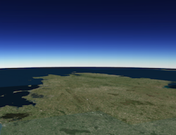
high 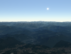
optionalstarsEnabled BooleanDefault Value:trueIndicates whether stars visualization is enabled.
The extent represents the visible portion of a map within the view as an instance of Extent. Setting the extent immediately changes the view without animation. To animate the view, see goTo().
Rather than using extent to change the visible portion of the map in a SceneView, you should use camera since it easily allows you to define the heading, elevation and tilt of the observation point from which the view's perspective is created.
When set in the constructor, this property overrides the center, scale, and zoom properties. This property will be ignored if the viewpoint or camera are also set in the constructor.
The extent property contains an internal reference which may be modified in the future. To persist or modify the extent, create a clone using extent.clone().
Z-values defined in a geographic or metric coordinate system are expressed in meters. However, in local scenes that use a projected coordinate system, vertical units are assumed to be the same as the horizontal units specified by the service.
- Since: ArcGIS API for JavaScript 4.12
A fatal error returned when the view loses its WebGL context. Watch this property to properly handle the error and attempt to recover the WebGL context.
- See also:
Example:view.watch("fatalError", function(error) { if(error) { console.error("Fatal Error! View has lost its WebGL context. Attempting to recover..."); view.tryFatalErrorRecovery(); } });
- Since: ArcGIS API for JavaScript 4.7
Indicates if the browser focus is on the view.
- graphics Collection<Graphic> inherited
Allows for adding graphics directly to the default graphics in the View.
Examples:// Adds a graphic to the View view.graphics.add(pointGraphic);// Removes a graphic from the View view.graphics.remove(pointGraphic);
- groundView GroundViewreadonlySince: ArcGIS API for JavaScript 4.7
The view for the ground of the map.
The height of the view in pixels read from the view container element.
The view container needs to have a height greater than 0 to be displayed.
- Default Value:0
- heightBreakpoint String
A convenience property indicating the general size of the view's height. This value is determined based on where the view's height falls in the ranges defined in the breakpoints property. See the table below for a list of possible values. Use the breakpoints property to override the default thresholds.
Please refer to the styling guide for additional information on working with this.
Possible Value Description Default thresholds (pixels) xsmall The height of the view is smaller than the value set in the xsmallbreakpoint.< 545 small The height of the view is between the values set in the xsmallandsmallbreakpoints.545 - 768 medium The height of the view is between the values set in the smallandmediumbreakpoints.769 - 992 large The height of the view is between the values set in the mediumandlargebreakpoints.993 - 1200 xlarge The height of the view is larger than the value set in the largebreakpoint.> 1200 Possible Values:"xsmall"|"small"|"medium"|"large"|"xlarge"
Example:view.watch("heightBreakpoint", function(newVal){ if (newVal === "xsmall"){ // clear the view's default UI components if // app is used on a mobile device view.ui.components = []; } });
- Since: ArcGIS API for JavaScript 4.4
Options for configuring the highlight. Use the highlight method on the appropriate LayerView to highlight a feature.
- Properties:
- optionalcolor ColorDefault Value:#00ffff
The color of the highlight.
optionalhaloColor ColorDefault Value:nullAn optional color for the halo of the highlight. If unset, the
colorwill be used for the halo.optionalhaloOpacity NumberDefault Value:1The opacity of the highlight halo. This will be multiplied with the opacity specified in
color.optionalfillOpacity NumberDefault Value:0.25The opacity of the fill (area within the halo). This will be multiplied with the opacity specified in
color. - See also:
Example:var view = new SceneView({ map: map, highlightOptions: { color: [255, 255, 0, 1], haloColor: "white", haloOpacity: 0.9, fillOpacity: 0.2 } });
- Since: ArcGIS API for JavaScript 4.9
Options to configure input handling of the View.
Example:// Make gamepad events to emit independently of focus. view.input.gamepad.enabledFocusMode = "none";
Indication whether the view is being interacted with (for example when panning).
- Default Value:false
- layerViews Collection<LayerView> inherited
A collection containing a hierarchical list of all the created LayerViews of the operational layers in the map.
- See also:
An instance of a Map object to display in the view. A view may only display one map at a time. On the other hand, one Map may be viewed by multiple MapViews and/or SceneViews simultaneously.
This property is typically set in the constructor of the MapView or SceneView. See the class description for examples demonstrating the relationship between the map and the view.
- orientation Stringreadonly
A convenience property indicating the view's orientation. See the table below for a list of possible values.
Please refer to the styling guide for additional information on working with this.
Possible Value Description landscape The width of the view is greater than its height. portrait The width of the view is equal to or smaller than its height. Possible Values:"landscape"|"portrait"
Use the padding property to make the center, and extent, etc. work off a subsection of the full view. This is particularly useful when layering UI elements or semi-transparent content on top of portions of the view. See the view padding sample for an example of how this works.
A Popup object that displays general content or attributes from layers in the map.
The view has a default instance of Popup with predefined styles and a template for defining content. The content in this default instance may be modified directly in the popup's content or in a layer's PopupTemplate.
You may create a new Popup instance and set it to this property to customize the style, positioning, and content of the popup in favor of using the default popup instance on the view.
Examples:// This syntax prevents any popups from opening and removes them from the application view.popup = null;// This syntax disables the click event on the view view.popup.autoOpenEnabled = false;
- qualityProfile String
SceneView can draw scenes in three different quality modes:
high,mediumandlow.The
lowquality profile significantly increases performance on slower browsers and devices by reducing the memory limit and the visual quality in the following aspects:- Map resolution
- Scene layer detail level
- Anti-aliasing (edge smoothing)
The high and medium quality profiles differ in the maximum amount of memory which the view is allowed to use. A higher memory limit improves quality in complex web scenes with many layers, but can have a negative impact on drawing performance and stability.
Physically based rendering (PBR) materials are enabled on all 3D objects in a SceneView in "high" quality mode. However, if a GLTF model or a 3D Object SceneLayer has PBR settings defined on the material, then these will be rendered in all quality modes.
In "high" quality mode, on a HiDPI display, graphics are rendered at a higher resolution depending on the browser's devicePixelRatio property.
The default value is based on the detected browser:
lowfor Internet Explorer 11 and certain mobile devicesmediumfor any other browser
Overriding the default value is best done in the constructor (see example below). If the value is modified after construction, only a subset of the quality aspects are affected.
Possible Values:"low"|"medium"|"high"
Example:var view = new SceneView({ qualityProfile: "high" });
When
true, this property indicates whether the view successfully satisfied all dependencies, signaling that the following conditions are met.- The view has a map. If map is a WebMap or a WebScene, then the map or scene must be loaded.
- The view has a container with a size greater than
0. - The view has a spatialReference, a center, and a scale. These also can be inferred by setting an extent.
When a view becomes ready it will resolve itself and invoke the callback defined in when() where code can execute on a working view. Subsequent changes to a view's readiness would typically be handled by watching
view.readyand providing logic for cases where the map or container change.- Default Value:false
- See also:
Indicates if the view is being resized.
- Default Value:false
- Since: ArcGIS API for JavaScript 4.9
Represents the current value of one pixel in the unit of the view's spatialReference. The value of resolution is calculated by dividing the view's extent width by its width.
- scale Number
Represents an approximation of the map scale at the center of the view. Setting the scale immediately changes the current view. For animating the view, see goTo().
When set in the constructor, this property overrides the zoom property. This property will be ignored if the viewpoint, camera, or extent properties are also set in the constructor.
- See also:
Example:// Set the approximate map scale at the center the view to 1:24,000 view.scale = 24000;
An array containing the width and height of the view in pixels, e.g.
[width, height].
The spatial reference of the view. This indicates the Projected Coordinate System or the Geographic Coordinate System used to locate geographic features in the map. In a SceneView the following supported coordinate systems are available.
The spatial reference can either be set explicitly or automatically derived from the following:
- In the case of a SceneView, if the map is a WebScene instance, the WebScene.initialViewProperties.spatialReference is used.
- In all other cases, the spatial reference is derived from the first layer that loads in this order:
When using an Esri basemap, the default spatial reference is Web Mercator Auxiliary Sphere.
- Default Value:null
Indication whether the view is animating, being interacted with or resizing.
Indicates if the view is visible on the page. Is
trueif the view has no container, a height or width equal to 0, or the CSSvisibilityishidden.- Default Value:true
- Since: ArcGIS API for JavaScript 4.12
The view's time extent. Time-aware layers display their temporal data that falls within the view's time extent. Setting the view's time extent is similar to setting the spatial extent because once the time extent is set, the view updates automatically to conform to the change.
- Default Value:null
Example:// Create a csv layer from an online spreadsheet. var csvLayer = new CSVLayer({ url: "http://test.com/daily-magazines-sold-in-new-york.csv", timeInfo: { startField: "SaleDate" // The csv field contains date information. } }); // Create a mapview showing sales for the last week of March 2019 only. var view = new MapView({ map: map, container: "viewDiv", timeExtent: { start: new Date("2019, 2, 24"), end: new Date("2019, 2, 31") } });
- type Stringreadonly
The type of the view (for SceneView, this value is always
3d).
Exposes the default widgets available in the view and allows you to toggle them on and off. See DefaultUI for more details.
Examples:var toggle = new BasemapToggle({ view: view, nextBasemap: "hybrid" }); // Adds an instance of BasemapToggle widget to the // top right of the view. view.ui.add(toggle, "top-right");// Moves the zoom and BasemapToggle widgets to the // bottom left of the view. view.ui.move([ "zoom", toggle ], "bottom-left");// Removes all the widgets from the bottom left of the view view.ui.empty("bottom-left");// Removes the compass widget from the view view.ui.remove("compass");// Removes all default UI components, except Attribution. // Passing an empty array will remove all components. view.ui.components = [ "attribution" ];
Indicates whether the view is being updated by additional data requests to the network, or by processing received data.
- Default Value:false
- viewingMode String
The viewing mode (
localorglobal). Global scenes render the earth as a sphere. Local scenes render the earth on a flat plane and allow for navigation and feature display in a localized or clipped area. Users may also navigate the camera of a local scene below the surface of a basemap.Value Example Description global 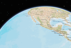
Global scenes allow the entire globe to render in the view, showing the curvature of the earth. local 
Local scenes render the earth on a flat surface. They can be constrained to only show a "local" area by setting the clippingArea property. Local scenes also allow for displaying and exploring data that would otherwise be hidden by the surface of the earth. Depending on the viewing mode different supported coordinate systems are available.
Possible Values:"global"|"local"
- Default Value:global
- See also:
Represents the current view as a Viewpoint or point of observation on the view. In SceneViews, camera should be used in favor of viewpoint for watching or changing the point of view. Setting the viewpoint immediately changes the current view. For animating the view, see goTo().
When set in the constructor, this property overrides the extent, center, scale, and zoom properties. This property will be ignored if camera is also set in the constructor.
The viewpoint property contains an internal reference which may be modified in the future. To persist or modify the viewpoint, create a clone using viewpoint.clone().
- See also:
The width of the view in pixels read from the view container element.
The view container needs to have a width greater than 0 to be displayed.
- Default Value:0
- widthBreakpoint String
A convenience property indicating the general size of the view's width. This value is determined based on where the view's width falls in the ranges defined in the breakpoints property. See the table below for a list of possible values. Use the breakpoints property to override the default thresholds.
Please refer to the styling guide for additional information on working with this.
Possible Value Description Default thresholds (pixels) xsmall The width of the view is smaller than the value set in the xsmallbreakpoint.< 545 small The width of the view is between the values set in the xsmallandsmallbreakpoints.545 - 768 medium The width of the view is between the values set in the smallandmediumbreakpoints.769 - 992 large The width of the view is between the values set in the mediumandlargebreakpoints.993 - 1200 xlarge The width of the view is larger than the value set in the largebreakpoint.> 1200 Possible Values:"xsmall"|"small"|"medium"|"large"|"xlarge"
Example:view.watch("widthBreakpoint", function(newVal){ if (newVal === "xsmall"){ // clear the view's default UI components if // app is used on a mobile device view.ui.components = []; } });
- zoom Number
Represents the level of detail (LOD) at the center of the view. Setting the zoom immediately changes the current view. For animating the view, see goTo().
Setting this property in conjunction with center is a convenient way to set the initial extent of the view.
If set in the constructor, this property will be ignored if the viewpoint, camera, extent, or scale properties are also set in the constructor.
- See also:
Examples:view.zoom = 3; // Sets the LOD to 3 (small map scale) view.zoom = 18; // Sets the LOD to 18 (large map scale)// Set the zoom level and center in the constructor var view = new SceneView({ zoom: 10, center: [-120, 34], map: map });
Method Overview
| Name | Return Type | Summary | Class | |
|---|---|---|---|---|
| Boolean | Emits an event on the instance. more details | more details | View | |
Sets the focus on the view. more details | more details | View | ||
| Promise | Sets the view to a given target. more details | more details | SceneView | |
| Boolean | Indicates whether there is an event listener on the instance that matches the provided event name. more details | more details | View | |
| Promise<HitTestResult> | Returns graphics that intersect the specified screen coordinate. more details | more details | SceneView | |
| Boolean |
| more details | View | |
| Boolean |
| more details | View | |
| Boolean |
| more details | View | |
| Object | Registers an event handler on the instance. more details | more details | View | |
| Promise<Screenshot> | Create a screenshot of the current view. more details | more details | SceneView | |
| Point | Converts the given screen point to a map point. more details | more details | SceneView | |
| ScreenPoint | Converts the given map point to a screen point. more details | more details | SceneView | |
Call this method to clear any fatal errors resulting from a lost WebGL context. more details | more details | View | ||
| Promise |
| more details | View | |
| Promise<LayerView> | Gets the LayerView created on the view for the given layer. more details | more details | View |
Method Details
- Since: ArcGIS API for JavaScript 4.5
Emits an event on the instance. This method should only be used when creating subclasses of this class.
Parameters:type StringThe name of the event.
event ObjectoptionalThe event payload.
Returns:Type Description Boolean trueif a listener was notified
- focus()inheritedSince: ArcGIS API for JavaScript 4.5
Sets the focus on the view.
- goTo(target, options){Promise}
Sets the view to a given target. The target parameter can be one of the following:
[longitude, latitude]pair of coordinates- Geometry (or array of Geometry[])
- Graphic (or array of Graphic[])
- Viewpoint
- Camera
- Object with a combination of
target,center,scale,position,headingandtiltproperties (withtargetbeing any of the types listed above). Thecenterproperty is provided as a convenience to animate the SceneView.center and is the equivalent of specifying thetargetwith the center Point. The target must be provided in the spatial reference of the view.
This function returns a promise which resolves as soon as the new view has been set to the target. If the transition is animated, then the ongoing animation can be obtained using SceneView.animation.
If the given target is far away from the current camera position, then heading and tilt will be automatically set to their neutral values (facing north, looking top down). Tilt and heading can always be explicitly set to override this behavior.
Parameters:target GoToTarget3DThe target location/viewpoint to go to. When using an object for
target, use the properties defined in GoToTarget3D.options GoToOptions3DoptionalView transition options. See the specification defined in GoToOptions3D for more information.
Returns:Type Description Promise A promise that resolves when the view's extent updates to the extent defined in target.- See also:
Examples:view.goTo({ center: [-126, 49], heading: 180, // set the heading to point South tilt: view.camera.tilt, // maintain tilt value })// go to a location defined by a Camera object var cam = new Camera({ position: new Point({ x: -100.23, // lon y: 65, // lat z: 10000, // elevation in meters }), heading: 180, // facing due south tilt: 45 // bird's eye view }); view.goTo(cam);// go to a point using center, zoom, tilt, and heading view.goTo({ center: [-126, 49], zoom: 13, tilt: 75, heading: 105 });// goTo returns a Promise which resolves when the animation has finished. // This promise may be chained to create a sequence of animations. view.goTo(graphic1) .then(function() { return view.goTo(graphic2); }) .then(function() { return view.goTo(graphic3); });// goTo returns a Promise which resolves when the animation has finished. // This promise may be chained to create a sequence of animations. view.goTo(graphic1) .then(function() { return view.goTo(graphic2); }) .then(function() { return view.goTo(graphic3); });
Indicates whether there is an event listener on the instance that matches the provided event name.
Parameter:type StringThe name of the event.
Returns:Type Description Boolean Returns true if the class supports the input event.
- hitTest(screenPoint, options){Promise<HitTestResult>}
Returns graphics that intersect the specified screen coordinate. The following layer types will return a result if a hit is made on an intersecting feature: GraphicsLayer, FeatureLayer, SceneLayer, BuildingSceneLayer, PointCloudLayer, CSVLayer, StreamLayer, GeoJSONLayer and SceneView.graphics.
If no options are specified, graphics that are behind the ground surface will not be returned unless the ground surface is semi-transparent. Otherwise, using the map.ground in the include and exclude options determines whether the ground surface prevents hit testing graphics that are under it.
Starting with version 4.11, if a label intersects the specified screen coordinates then the result of the hitTest will contain the graphic associated with that label.
Parameters:Specification:screenPoint ScreenPoint|MouseEventThe screen coordinates (or native mouse event) of the click on the view.
options ObjectoptionalIntersection test options. By default the map.ground is excluded if its opacity is smaller than one.
Specification:include Array<(IntersectItem|Collection<IntersectItem>|Array<IntersectItem>|Ground)>|Collection<IntersectItem>|IntersectItemoptionalA list of layers and graphics to include for intersection testing. All layers and graphics will be included if include is not specified.
exclude Array<(IntersectItem|Collection<IntersectItem>|Array<IntersectItem>|Ground)>|Collection<IntersectItem>|IntersectItemoptionalA list of layers and graphics to include for intersection testing. No layers or graphics will be excluded if exclude is not specified.
Returns:Type Description Promise<HitTestResult> When resolved, returns an object containing the graphics (if present) that intersect the given screen coordinates. Example:// Get the screen point from the view's click event view.on("click", function(event) { // Search for graphics at the clicked location. View events can be used // as screen locations as they expose an x,y coordinate that conforms // to the ScreenPoint definition. view.hitTest(event).then(function(response) { var result = response.results[0]; if (result) { var lon = result.mapPoint.longitude; var lat = result.mapPoint.latitude; console.log("Hit graphic at (" + lon + ", " + lat + ")", result.graphic); } else { console.log("Did not hit any graphic"); } }); });
isFulfilled()may be used to verify if creating an instance of the class is fulfilled (either resolved or rejected). If it is fulfilled,truewill be returned.Returns:Type Description Boolean Indicates whether creating an instance of the class has been fulfilled (either resolved or rejected).
isRejected()may be used to verify if creating an instance of the class is rejected. If it is rejected,truewill be returned.Returns:Type Description Boolean Indicates whether creating an instance of the class has been rejected.
isResolved()may be used to verify if creating an instance of the class is resolved. If it is resolved,truewill be returned.Returns:Type Description Boolean Indicates whether creating an instance of the class has been resolved.
Registers an event handler on the instance. Call this method to hook an event with a listener. See the Events summary table for a list of listened events.
Parameters:The name of the event or events to listen for.
Additional modifier keys to filter events. Please see Key Values for possible values. All the standard key values are supported. Alternatively, if no modifiers are required, the function will call when the event fires.
The following events don't support modifier keys:
blur,focus,layerview-create,layerview-destroy,resize.handler FunctionoptionalThe function to call when the event is fired, if modifiers were specified.
Returns:Type Description Object Returns an event handler with a remove()method that can be called to stop listening for the event.Property Type Description remove Function When called, removes the listener from the event. Example:view.on("click", function(event){ // event is the event handle returned after the event fires. console.log(event.mapPoint); }); // Fires `pointer-move` event when user clicks on "Shift" // key and moves the pointer on the view. view.on('pointer-move', ["Shift"], function(evt){ var point = view2d.toMap({x: evt.x, y: evt.y}); bufferPoint(point); });
- takeScreenshot(options){Promise<Screenshot>}Since: ArcGIS API for JavaScript 4.9
Create a screenshot of the current view. Screenshots include only elements that are rendered on the canvas (all geographical elements), but excludes overlayed DOM elements (UI, popups, etc.). By default, a screenshot of the whole view is created. Different options allow for creating different types of screenshots, including taking screenshots at different aspect ratios, different resolutions and creating thumbnails.
Screenshots are always taken inside the padded area of the view (see padding).
Parameters:Specification:options ObjectoptionalScreenshot options.
Specification:format StringoptionalDefault Value: jpgThe format of the resulting encoded data url.
Possible values: jpg | png.
quality NumberoptionalDefault Value: 98The quality (0 to 100) of the encoded image when format is
jpg.width NumberoptionalThe width of the screenshot (defaults to the area width). The height will be derived automatically if left unspecified, according to the aspect ratio of the of the screenshot area.
height NumberoptionalThe height of the screenshot (defaults to the area height). The width will be derived automatically if left unspecified, according to the aspect ratio of the screenshot area.
area ObjectoptionalSpecifies whether to take a screenshot of a specific area of the view. The area coordinates are relative to the origin of the padded view (see padding) and will be clipped to the view size. Defaults to the whole view (padding excluded).
Specification:x NumberoptionalThe x coordinate of the area.
y NumberoptionalThe y coordinate of the area.
width NumberoptionalThe width of the area.
height NumberoptionalThe height of the area.
ignorePadding BooleanoptionalIndicates whether view padding should be ignored. Set this property to
trueto allow padded areas to be included in the screenshot.Returns:Type Description Promise<Screenshot> When resolved, returns an object containing an encoded dataUrl and raw image data. Examples:// Take a screenshot at the same resolution of the current view view.takeScreenshot().then(function(screenshot) { var imageElement = document.getElementById("screenshotImage"); imageElement.src = screenshot.dataUrl; });// Create a square thumbnail from the current view var options = { width: 200, height: 200 }; view.takeScreenshot(options).then(function(screenshot) { var imageElement = document.getElementById("screenshotImage"); imageElement.src = screenshot.dataUrl; });// Take a high resolution, square screenshot var options = { width: 2048, height: 2048 }; view.takeScreenshot(options).then(function(screenshot) { var imageElement = document.getElementById("screenshotImage"); imageElement.src = screenshot.dataUrl; });// Take a screenshot of a small area at the center of the view // Compute the size of the view excluding potential padding var padding = view.padding; var innerWidth = view.width - padding.left - padding.right; var innerHeight = view.height - padding.top - padding.bottom; // Desired size of the area var width = 200; var height = 200; var options = { area: { x: (innerWidth - width) / 2, y: (innerHeight - height) / 2, width: width, height: height } }; view.takeScreenshot(options).then(function(screenshot) { var imageElement = document.getElementById("screenshotImage"); imageElement.src = screenshot.dataUrl; });// Takes a high-resolution screenshot for display on a HiDPI screen // The pixelRatio indicates the display has 2x the pixel density of typical screens var pixelRatio = 2; view.takeScreenshot({ width: view.width * pixelRatio, height: view.height * pixelRatio });// Takes a high-resolution screenshot for display on a HiDPI screen // The pixelRatio is the resolution of the display capturing the image var pixelRatio = window.devicePixelRatio; view.takeScreenshot({ width: view.width * pixelRatio, height: view.height * pixelRatio });
- toMap(screenPoint, options){Point}
Converts the given screen point to a map point.
Parameters:Specification:screenPoint ScreenPoint|MouseEventThe location on the screen (or native mouse event) to convert.
options ObjectoptionalIntersection test options. By default only the map.ground and any IntegratedMeshLayer are included.
Specification:include Array<(IntersectItem|Collection<IntersectItem>|Array<IntersectItem>|Ground)>|Collection<IntersectItem>|IntersectItemoptionalA list of layers and graphics to include for intersection testing. All layers and graphics will be included if include is not specified.
exclude Array<(IntersectItem|Collection<IntersectItem>|Array<IntersectItem>|Ground)>|Collection<IntersectItem>|IntersectItemoptionalA list of layers and graphics to include for intersection testing. No layers or graphics will be excluded if exclude is not specified.
Returns:Type Description Point The map point corresponding to the given screen point.
- toScreen(point){ScreenPoint}
Converts the given map point to a screen point.
Parameter:point PointA point geometry.
Returns:Type Description ScreenPoint The screen point corresponding to the given map point.
- tryFatalErrorRecovery()inheritedSince: ArcGIS API for JavaScript 4.12
Call this method to clear any fatal errors resulting from a lost WebGL context.
- See also:
Example:view.watch("fatalError", function(error) { if(error) { view.tryFatalErrorRecovery(); } });
- Since: ArcGIS API for JavaScript 4.6
when()may be leveraged once an instance of the class is created. This method takes two input parameters: acallbackfunction and anerrbackfunction. Thecallbackexecutes when the instance of the class loads. Theerrbackexecutes if the instance of the class fails to load.Parameters:callback FunctionoptionalThe function to call when the promise resolves.
errback FunctionoptionalThe function to execute when the promise fails.
Returns:Type Description Promise Returns a new promise for the result of callbackthat may be used to chain additional functions.Example:// Although this example uses MapView, any class instance that is a promise may use then() in the same way var view = new MapView(); view.when(function(){ // This function will execute once the promise is resolved }, function(error){ // This function will execute if the promise is rejected due to an error });
Gets the LayerView created on the view for the given layer. The returned promise resolves when the layer view for the given layer has been created, or rejects with an error (for example if the layer is not part of the view, or if the layer type is not supported in this view).
Parameter:layer LayerThe layer for which to obtain its LayerView.
Returns:Type Description Promise<LayerView> Resolves to an instance of LayerView for the specified layer. - See also:
Example:// Create a feature layer from a url pointing to a Feature Service var layer = new FeatureLayer(url); map.add(layer); view.whenLayerView(layer) .then(function(layerView) { // The layerview for the layer }) .catch(function(error) { // An error occurred during the layerview creation });
Type Definitions
- EasingFunction(t, duration){Number}
User provided easing function. The function receives a normalized time between 0 and 1 as input and should provide a transformed normalized time between 0 and 1 as output.
Parameters:t NumberThe input time (from 0 to 1)
duration NumberThe total duration (in milliseconds) of the animation. This may be used for heuristics on deciding what type of easing to perform.
Returns:Type Description Number a value between 0 and 1 Example:// Simple quadratic ease in function function easeIn(t) { return t * t; }
- GoToOptions3D Object
Animation options for the goTo() method. See properties below for parameter specifications.
- Properties:
- optionalanimate BooleanDefault Value:true
Indicates if the transition to the new view should be animated. If set to false,
speedFactor,duration,maxDuration, andeasingproperties are ignored.optionalspeedFactor NumberDefault Value:1Increases or decreases the animation speed by the specified factor. A speedFactor of 2 will make the animation twice as fast, while a speedFactor of 0.5 will make the animation half as fast. Setting the speed factor will automatically adapt the default maxDuration accordingly.
optionalduration NumberSet the exact duration (in milliseconds) of the animation. Note that by default, animation duration is calculated based on the time required to reach the target at a constant speed. Setting duration overrides the speedFactor option. Note that the resulting duration is still limited to the maxDuration.
optionalmaxDuration NumberDefault Value:8000The maximum allowed duration (in milliseconds) of the animation. The default maxDuration value takes the specified speedFactor into account.
optionaleasing String|EasingFunctionThe easing function to use for the animation. This may either be a preset (named) function, or a user specified function. Supported named presets are:
linear,in-cubic,out-cubic,in-out-cubic,in-expo,out-expo,in-out-expo,in-out-coast-quadratic. See easing functions for graphical representations of these functions.By default, animations that are less than 1000 ms use the
out-expoeasing function; longer animations use thein-out-coast-quadraticeasing function.optionalsignal AbortSignalAn AbortSignal to abort the animation. If canceled, the promise will be rejected with an error named
AbortError. See also AbortController.
The target location/viewpoint to animate to in the goTo() method. A two or three-element array of numbers represents the [x,y,z] coordinates to center the view on. When using an object for the
target, use the properties in the table below.- Properties:
- optional
The target of the animation.
optional The SceneView.center to go to.
optionalscale NumberThe SceneView.scale to go to.
optionalzoom NumberThe final zoom value to go to.
optionalheading NumberThe Camera.heading to go to.
optionaltilt NumberThe Camera.tilt to go to.
optionalposition PointThe Camera.position to go to.
- HitTestResult
Object specification for the result of the hitTest() method.
- Properties:
An array of result objects returned from the hitTest(). Results are returned when the location of the input screen coordinates intersect a Graphic in the view. See the table below for the specification of each object in this array.
- Specification:
- graphic Graphic
A graphic present in the view that intersects the input screen coordinates. Starting with version 4.11, if a label intersects the input screen coordinates the corresponding graphic is returned. If the graphic comes from a layer with an applied Renderer, then the symbol property will be empty. Other properties will be empty based on the context in which the graphic is fetched. Some layers do not have a graphic.geometry (for example: SceneLayer and PointCloudLayer
PointCloudLayer) The graphic.attributes only includes attributes which are loaded by the client, for this reason it can be a subset of all attributes. FeatureLayer.outFields with["*"]can be used to force all attributes to be present. The graphic.symbol exists only for graphics coming from GraphicsLayer or view.graphics but it is possible to compute the displayed symbology with getDisplayedSymbol.mapPoint PointThe point geometry in the spatial reference of the view corresponding with the input screen coordinates.
distance NumberThe distance from the camera position to the point geometry hit on this graphic. In global scenes the distance will be in meters while in local scenes the distance will be in the unit of the spatial reference of the view.
ground ObjectGround intersection result. The ground hit result will always be returned, even if the ground was excluded from the hitTest.
- Specification:
- mapPoint Point
The point at which the ground was hit while performing the hitTest. This may be
nullwhen the ground was not hit at all (for example by clicking on the sky).distance NumberThe distance from camera position to the ground hit. The distance will be
0if the ground was not hit at all. In global scenes the distance will be in meters while in local scenes the distance will be in the unit of the spatial reference of the view.
screenPoint ScreenPoint|MouseEventThe screen coordinates (or native mouse event) of the click on the view.
- ScreenPointSince: ArcGIS API for JavaScript 4.11
An object representing a point on the screen.
- ScreenshotSince: ArcGIS API for JavaScript 4.9
Object returned when takeScreenshot() promise resolves:
Event Overview
| Name | Type | Summary | Class | |
|---|---|---|---|---|
{target: View,native: Object} | Fires when browser focus is moved away from the view. more details | more details | View | |
{mapPoint: Point,x: Number,y: Number,button: Number,buttons: 0,1,2,type: "click",stopPropagation: Function,timestamp: Number,native: Object} | Fires after a user clicks on the view. more details | more details | View | |
{mapPoint: Point,x: Number,y: Number,button: Number,buttons: 0,1,2,type: "double-click",stopPropagation: Function,timestamp: Number,native: Object} | Fires after double-clicking on the view. more details | more details | View | |
{action: "start","added","update","removed","end",x: Number,y: Number,origin: Object,button: 0,1,2,buttons: Number,type: "drag",radius: Number,angle: Number,stopPropagation: Function,timestamp: Number,native: Object} | Fires during a pointer drag on the view. more details | more details | View | |
{target: View,native: Object} | Fires when browser focus is on the view. more details | more details | View | |
{mapPoint: Point,x: Number,y: Number,button: 0,1,2,buttons: Number,type: "hold",stopPropagation: Function,timestamp: Number,native: Object} | Fires after holding either a mouse button or a single finger on the view for a short amount of time. more details | more details | View | |
{mapPoint: Point,x: Number,y: Number,button: 0,1,2,buttons: Number,type: "immediate-click",stopPropagation: Function,timestamp: Number,native: Object} | Fires right after a user clicks on the view. more details | more details | View | |
{repeat: Boolean,key: String,type: "key-down",stopPropagation: Function,timestamp: Number,native: Object} | Fires after a keyboard key is pressed. more details | more details | View | |
{type: "key-up",key: String,stopPropagation: Function,timestamp: Number,native: Object} | Fires after a keyboard key is released. more details | more details | View | |
{layer: Layer,layerView: LayerView} | Fires after each layer in the map has a corresponding LayerView created and rendered in the view. more details | more details | View | |
{layer: Layer,error: Error} | Fires when an error emits during the creation of a LayerView after a layer has been added to the map. more details | more details | View | |
{layer: Layer,layerView: LayerView} | Fires after a LayerView is destroyed and is no longer rendered in the view. more details | more details | View | |
{x: Number,y: Number,deltaY: Number,type: "mouse-wheel",stopPropagation: Function,timestamp: Number,native: Object} | Fires when a wheel button of a pointing device (typically a mouse) is scrolled on the view. more details | more details | View | |
{pointerId: Number,pointerType: "mouse","touch",x: Number,y: Number,button: Number,buttons: Number,type: "pointer-down",stopPropagation: Function,timestamp: Number,native: Object} | Fires after a mouse button is pressed, or a finger touches the display. more details | more details | View | |
{pointerId: Number,pointerType: "mouse","touch",x: Number,y: Number,button: Number,buttons: Number,type: "pointer-enter",stopPropagation: Function,timestamp: Number,native: Object} | Fires after a mouse cursor enters the view, or a display touch begins. more details | more details | View | |
{pointerId: Number,pointerType: "mouse","touch",x: Number,y: Number,button: Number,buttons: Number,type: "pointer-leave",stopPropagation: Function,timestamp: Number,native: Object} | Fires after a mouse cursor leaves the view, or a display touch ends. more details | more details | View | |
{pointerId: Number,pointerType: "mouse","touch",x: Number,y: Number,button: Number,buttons: Number,type: "pointer-move",stopPropagation: Function,timestamp: Number,native: Object} | Fires after the mouse or a finger on the display moves. more details | more details | View | |
{pointerId: Number,pointerType: "mouse","touch",x: Number,y: Number,button: Number,buttons: Number,type: "pointer-up",stopPropagation: Function,timestamp: Number,native: Object} | Fires after a mouse button is released, or a display touch ends. more details | more details | View | |
{oldWidth: Number,oldHeight: Number,width: Number,height: Number} | Fires when the view's size changes. more details | more details | View |
Event Details
- blurinheritedSince: ArcGIS API for JavaScript 4.7
Fires when browser focus is moved away from the view.
- Properties:
- target View
The view that the browser focus is moved away from.
native ObjectA standard DOM KeyboardEvent.
- clickinherited
Fires after a user clicks on the view. This event emits slightly slower than a pointer-down event to make sure that a double-click event isn't triggered instead. The immediate-click event can be used for responding to a click event without delay.
- Properties:
- mapPoint Point
The point location of the click on the view in the spatial reference of the map.
x NumberThe horizontal screen coordinate of the click on the view.
y NumberThe vertical screen coordinate of the click on the view.
button NumberIndicates which mouse button was clicked.
buttons NumberIndicates the current mouse button state.
Value Description 0 left click (or touch) 1 middle click 2 right click type StringFor click the type is always
click.The value is always "click".
stopPropagation FunctionPrevents the event bubbling up the event chain.
timestamp NumberTime stamp (in milliseconds) at which the event was emitted.
native ObjectA standard DOM PointerEvent.
- See also:
Examples:// Set up a click event handler and retrieve the screen point view.on("click", function(event) { // the hitTest() checks to see if any graphics in the view // intersect the given screen x, y coordinates view.hitTest(event) .then(getGraphics); });view.on("click", function(event) { // you must overwrite default click-for-popup // behavior to display your own popup view.popup.autoOpenEnabled = false; // Get the coordinates of the click on the view var lat = Math.round(event.mapPoint.latitude * 1000) / 1000; var lon = Math.round(event.mapPoint.longitude * 1000) / 1000; view.popup.open({ // Set the popup's title to the coordinates of the location title: "Reverse geocode: [" + lon + ", " + lat + "]", location: event.mapPoint // Set the location of the popup to the clicked location content: "This is a point of interest" // content displayed in the popup }); });
- double-clickinherited
Fires after double-clicking on the view.
- Properties:
- mapPoint Point
The point location of the click on the view in the spatial reference of the map.
x NumberThe horizontal screen coordinate of the click on the view.
y NumberThe vertical screen coordinate of the click on the view.
button NumberIndicates which mouse button was clicked.
buttons NumberIndicates the current mouse button state.
Value Description 0 left click (or touch) 1 middle click 2 right click type StringFor double-click the type is always
double-click.The value is always "double-click".
stopPropagation FunctionPrevents the event bubbling up the event chain.
timestamp NumberTime stamp (in milliseconds) at which the event was emitted.
native ObjectA standard DOM PointerEvent.
Example:view.on("double-click", function(event) { // The event object contains the mapPoint and the screen coordinates of the location // that was clicked. console.log("screen point", event.x, event.y); console.log("map point", event.mapPoint); });
- draginherited
Fires during a pointer drag on the view.
- Properties:
- action String
Indicates the state of the drag. The two values
addedandremovedindicate a change in the number of pointers involved.x NumberThe horizontal screen coordinate of the pointer on the view.
y NumberThe vertical screen coordinate of the pointer on the view.
origin ObjectScreen coordinates of the start of the drag.
button NumberIndicates which mouse button was clicked at the start of the drag. See MouseEvent.button.
Value Description 0 left mouse button (or touch) 1 middle mouse button 2 right mouse button buttons NumberIndicates which mouse buttons are pressed when the event is triggered. See MouseEvent.buttons.
type StringFor drag the type is always
drag.The value is always "drag".
radius NumberThe radius of a sphere around the multiple pointers involved in this drag. Or 0 while only a single pointer is used.
angle NumberAmount of rotation (in degrees) since the last event of type
start.stopPropagation FunctionPrevents the event bubbling up the event chain.
timestamp NumberTime stamp (in milliseconds) at which the event was emitted.
native ObjectA standard DOM MouseEvent.
Example:view.on("drag", function(evt){ // Print out the current state of the // drag event. console.log("drag state", evt.action); });
- focusinheritedSince: ArcGIS API for JavaScript 4.7
Fires when browser focus is on the view.
- Properties:
- target View
The view that the browser focus is currently on.
native ObjectA standard DOM KeyboardEvent.
- holdinherited
Fires after holding either a mouse button or a single finger on the view for a short amount of time.
- Properties:
- mapPoint Point
The point location of the click on the view in the spatial reference of the map.
x NumberThe horizontal screen coordinate of the hold on the view.
y NumberThe vertical screen coordinate of the hold on the view.
button NumberIndicates which mouse button was held down. See MouseEvent.button.
Value Description 0 left mouse button (or touch) 1 middle mouse button 2 right mouse button buttons NumberIndicates which mouse buttons are pressed when the event is triggered. See MouseEvent.buttons.
type StringFor hold the type is always
hold.The value is always "hold".
stopPropagation FunctionPrevents the event bubbling up the event chain.
timestamp NumberTime stamp (in milliseconds) at which the event was emitted.
native ObjectA standard DOM PointerEvent.
Example:view.on("hold", function(event) { // The event object contains the mapPoint and the screen coordinates of the location // that was clicked. console.log("hold at screen point", event.x, event.y); console.log("hold at map point", event.mapPoint); });
- immediate-clickinheritedSince: ArcGIS API for JavaScript 4.7
Fires right after a user clicks on the view. In contrast to the click event, the immediate-click event is emitted as soon as the user clicks on the view, and is not inhibited by a double-click event. This event is useful for interactive experiences that require feedback without delay.
- Properties:
- mapPoint Point
The point location of the click on the view in the spatial reference of the map.
x NumberThe horizontal screen coordinate of the click on the view.
y NumberThe vertical screen coordinate of the click on the view.
button NumberIndicates which mouse button was clicked. See MouseEvent.button.
Value Description 0 left click (or touch) 1 middle click 2 right click buttons NumberIndicates which buttons are pressed when the event is triggered. See MouseEvent.buttons.
type StringFor click the type is always
immediate-click.The value is always "immediate-click".
stopPropagation FunctionPrevents the event bubbling up the event chain. Inhibits the associated click and double-click events.
timestamp NumberTime stamp (in milliseconds) at which the event was emitted.
native ObjectA standard DOM PointerEvent.
Example:// Set up an immediate-click event handler and retrieve the screen point view.on("immediate-click", function(event) { // the hitTest() checks to see if any graphics in the view // intersect the given screen x, y coordinates view.hitTest(event) .then(getGraphics); });
- key-downinherited
Fires after a keyboard key is pressed.
- Properties:
- repeat Boolean
Indicates whether this is the first event emitted due to the key press, or a repeat.
key StringThe key value that was pressed, according to the MDN full list of key values.
type StringFor key-down the type is always
key-down.The value is always "key-down".
stopPropagation FunctionPrevents the event bubbling up the event chain.
timestamp NumberTime stamp (in milliseconds) at which the event was emitted.
native ObjectA standard DOM KeyboardEvent.
Example:// Zoom in when user clicks on "a" button // Zoom out when user clicks on "s" button view.on("key-down", function(evt){ console.log("key-down", evt); if (evt.key === "a"){ var zm = view.zoom + 1; view.goTo({ target: view.center, zoom: zm }); } else if(evt.key == "s"){ var zm = view.zoom - 1; view.goTo({ target: view.center, zoom: zm }); } });
- key-upinherited
Fires after a keyboard key is released.
- Properties:
- type String
For key-up the type is always
key-up.The value is always "key-up".
key StringThe key value that was released, according to the MDN full list of key values.
stopPropagation FunctionPrevents the event bubbling up the event chain.
timestamp NumberTime stamp (in milliseconds) at which the event was emitted.
native ObjectA standard DOM KeyboardEvent.
- layerview-createinherited
Fires after each layer in the map has a corresponding LayerView created and rendered in the view.
- Properties:
- layer Layer
The layer in the map for which the
layerViewwas created.layerView LayerViewThe LayerView rendered in the view representing the layer in
layer. - See also:
Example:// This function fires each time a layer view is created for a layer in // the map of the view. view.on("layerview-create", function(event) { // The event contains the layer and its layer view that has just been // created. Here we check for the creation of a layer view for a layer with // a specific id, and log the layer view if (event.layer.id === "satellite") { // The LayerView for the desired layer console.log(event.layerView); } });
- layerview-create-errorinherited
Fires when an error emits during the creation of a LayerView after a layer has been added to the map.
- Properties:
- layer Layer
The layer in the map for which the view emitting this event failed to create a layer view.
error ErrorAn error object describing why the layer view failed to create.
- See also:
Example:// This function fires each time an error occurs during the creation of a layerview view.on("layerview-create-error", function(event) { console.error("LayerView failed to create for layer with the id: ", event.layer.id); });
- layerview-destroyinherited
Fires after a LayerView is destroyed and is no longer rendered in the view. This happens for example when a layer is removed from the map of the view.
- mouse-wheelinherited
Fires when a wheel button of a pointing device (typically a mouse) is scrolled on the view.
- Properties:
- x Number
The horizontal screen coordinate of the click on the view.
y NumberThe vertical screen coordinate of the click on the view.
deltaY NumberNumber representing the vertical scroll amount.
type StringFor mouse-wheel the type is always
mouse-wheel.The value is always "mouse-wheel".
stopPropagation FunctionPrevents the event bubbling up the event chain.
timestamp NumberTime stamp (in milliseconds) at which the event was emitted.
native ObjectA standard DOM WheelEvent.
Example:view.on("mouse-wheel", function(evt){ // deltaY value is postive when wheel is scrolled up // and it is negative when wheel is scrolled down. console.log(evt.deltaY); });
- pointer-downinherited
Fires after a mouse button is pressed, or a finger touches the display.
- Properties:
- pointerId Number
Uniquely identifies a pointer between multiple down, move, and up events. Ids might get reused after a pointer-up event.
pointerType StringIndicates the pointer type.
x NumberThe horizontal screen coordinate of the pointer on the view.
y NumberThe vertical screen coordinate of the pointer on the view.
button NumberIndicates which mouse button was clicked.
buttons NumberIndicates which mouse buttons are pressed when the event is triggered. See MouseEvent.buttons.
type StringFor pointer-down the type is always
pointer-down.The value is always "pointer-down".
stopPropagation FunctionPrevents the event bubbling up the event chain.
timestamp NumberTime stamp (in milliseconds) at which the event was emitted.
native ObjectA standard DOM PointerEvent.
- pointer-enterinherited
Fires after a mouse cursor enters the view, or a display touch begins.
- Properties:
- pointerId Number
Uniquely identifies a pointer between multiple events. Ids might get reused after a pointer-up event.
pointerType StringIndicates the pointer type.
x NumberThe horizontal screen coordinate of the pointer on the view.
y NumberThe vertical screen coordinate of the pointer on the view.
button NumberIndicates which mouse button was clicked.
buttons NumberIndicates which mouse buttons are pressed when the event is triggered. See MouseEvent.buttons.
type StringType of the event. It is always
pointer-enterfor this event.The value is always "pointer-enter".
stopPropagation FunctionPrevents the event bubbling up the event chain.
timestamp NumberTime stamp (in milliseconds) at which the event was created.
native ObjectA standard DOM PointerEvent.
- pointer-leaveinherited
Fires after a mouse cursor leaves the view, or a display touch ends.
- Properties:
- pointerId Number
Uniquely identifies a pointer between multiple events. Ids might get reused after a pointer-up event.
pointerType StringIndicates the pointer type.
x NumberThe horizontal screen coordinate of the pointer on the view.
y NumberThe vertical screen coordinate of the pointer on the view.
button NumberIndicates which mouse button was clicked.
buttons NumberIndicates which mouse buttons are pressed when the event is triggered. See MouseEvent.buttons.
type StringType of the event. It is always
pointer-leavefor this event.The value is always "pointer-leave".
stopPropagation FunctionPrevents the event bubbling up the event chain.
timestamp NumberTime stamp (in milliseconds) at which the event was created.
native ObjectA standard DOM PointerEvent.
- pointer-moveinherited
Fires after the mouse or a finger on the display moves.
- Properties:
- pointerId Number
Uniquely identifies a pointer between multiple down, move, and up events. Ids might get reused after a pointer-up event.
pointerType StringIndicates the pointer type.
x NumberThe horizontal screen coordinate of the pointer on the view.
y NumberThe vertical screen coordinate of the pointer on the view.
button NumberIndicates which mouse button was clicked.
buttons NumberIndicates which mouse buttons are pressed when the event is triggered. See MouseEvent.buttons.
type StringType of the event. It is always
pointer-movefor this event.The value is always "pointer-move".
stopPropagation FunctionPrevents the event bubbling up the event chain.
timestamp NumberTime stamp (in milliseconds) at which the event was created.
native ObjectA standard DOM PointerEvent.
Example:// Fires `pointer-move` event when user clicks on "Shift" // key and moves the pointer on the view. view.on('pointer-move', ["Shift"], function(evt){ var point = view2d.toMap({x: evt.x, y: evt.y}); bufferPoint(point); });
- pointer-upinherited
Fires after a mouse button is released, or a display touch ends.
- Properties:
- pointerId Number
Uniquely identifies a pointer between multiple down, move, and up events. Ids might get reused after a pointer-up event.
pointerType StringIndicates the pointer type.
x NumberThe horizontal screen coordinate of the pointer on the view.
y NumberThe vertical screen coordinate of the pointer on the view.
button NumberIndicates which mouse button was clicked.
buttons NumberIndicates which mouse buttons are pressed when the event is triggered. See MouseEvent.buttons.
type StringType of the event. It is always
pointer-upfor this event.The value is always "pointer-up".
stopPropagation FunctionPrevents the event bubbling up the event chain. Inhibits the associated immediate-click, click and double-click events.
timestamp NumberTime stamp (in milliseconds) at which the event was created.
native ObjectA standard DOM PointerEvent.