SimpleLineSymbol
require(["esri/symbols/SimpleLineSymbol"], function(SimpleLineSymbol) { /* code goes here */ });esri/symbols/SimpleLineSymbolSimpleLineSymbol is used for rendering 2D polyline geometries in a 2D MapView. SimpleLineSymbol is also used for rendering outlines for marker symbols and fill symbols.
SimpleLineSymbol may also be used to symbolize 2D polyline features in a SceneView. However, it is recommended you use LineSymbol3D instead.
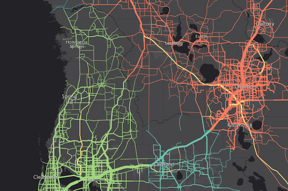
The image below depicts a FeatureLayer whose graphics are styled with SimpleLineSymbols.
Autocasting support
As of version 4.5 of the ArcGIS API for JavaScript, autocasting is universally supported for all renderers, symbols, and symbol layers in the API. So there is no need to include this module in the require() and define() module loaders of your application unless you intend to use the static method(s) of this module.
- See also:
// this symbol can be used to visualize polyline
// features or the outline of a fill symbol
var symbol = {
  type: "simple-line",  // autocasts as new SimpleLineSymbol()
  color: "lightblue",
  width: "2px",
  style: "short-dot"
};
Constructors
- new SimpleLineSymbol(properties)
- Parameter:properties Objectoptional
See the properties for a list of all the properties that may be passed into the constructor.
Property Overview
| Name | Type | Summary | Class | |
|---|---|---|---|---|
| String | Specifies the cap style. more details | more details | SimpleLineSymbol | |
| Color | The color of the symbol. more details | more details | Symbol | |
| String | The name of the class. more details | more details | Accessor | |
| String | Specifies the join style. more details | more details | SimpleLineSymbol | |
| Number | Maximum allowed ratio of the width of a miter join to the line width. more details | more details | SimpleLineSymbol | |
| String | Specifies the line style. more details | more details | SimpleLineSymbol | |
| String | The symbol type. more details | more details | SimpleLineSymbol | |
| Number | The width of the symbol in points. more details | more details | LineSymbol |
Property Details
- cap String
Specifies the cap style. The cap is the end node of a polyline, or the end of a line segment that does not connect with another segment of the same polyline.
See the table below for possible values.
Possible Value Example butt 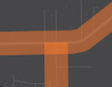
round 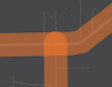
square 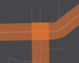
Known Limitations
- This property does not persist when applied to a symbol used in a layer saved to a web map or portal item. See the web map specification for more details about properties that persist when a SimpleLineSymbol is saved to an ArcGIS Online or Portal item.
Possible Values:"butt"|"round"|"square"
- Default Value:round
Example:symbol.cap = "square";
The color of the symbol. This can be autocast with an array of rgb(a) values, named string, hex string or an hsl(a) string, an object with
r,g,b, andaproperties, or a Color object.- Default Value:black
Examples:// CSS color string symbol.color = "dodgerblue";// HEX string symbol.color = "#33cc33";// array of RGBA values symbol.color = [51, 204, 51, 0.3];// object with rgba properties symbol.color = { r: 51, g: 51, b: 204, a: 0.7 };
- Since: ArcGIS API for JavaScript 4.7
The name of the class. The declared class name is formatted as
esri.folder.className.
- join String
Specifies the join style. A
joinrefers to the joint of a polyline, or the end of a line segment that connects to another segment of the same polyline. See the table below for possible values.Possible Value Example bevel 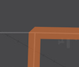
miter 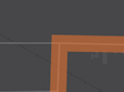
round 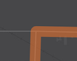
Possible Values:"miter"|"round"|"bevel"
- Default Value:round
Example:symbol.join = "bevel";
- miterLimit Number
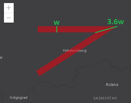
Maximum allowed ratio of the width of a miter join to the line width. Miter joins can get very wide at sharp line angles; this can be visually unpleasant or interfere with cartography. In the example below, the width of the miter join is about 3.6 times the width of the line.
A miter limit of
Xmeans that a miter join can be at mostXtimes as wide as the line itself. Beyond that threshold, it is replaced with a bevel join. Referring to the previous example, setting the miter limit to 3.6 or greater has no effect on the generated visuals; setting the miter limit to 3.5 or smaller causes the replacement with a bevel join.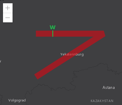
Known Limitations
This property is currently not supported in 3D SceneViews.
- Default Value:2
Example:// Miter joins that would be twice as wide as the line itself are // replaced by bevel joins. symbol.miterLimit = 2;
- style String
Specifies the line style. Possible values are listed in the table below:
Value Description dash 
dash-dot 
dot 
long-dash 
long-dash-dot 
long-dash-dot-dot 
none The line has no symbol. short-dash 
short-dash-dot 
short-dash-dot-dot 
short-dot 
solid 
Known Limitations
This property is currently not supported in 3D SceneViews.
Possible Values:"dash"|"dash-dot"|"dot"|"long-dash"|"long-dash-dot"|"long-dash-dot-dot"|"none"|"short-dash"|"short-dash-dot"|"short-dash-dot-dot"|"short-dot"|"solid"
- Default Value:solid
Example:symbol.style = "short-dash-dot";
- type Stringreadonly
The symbol type.
For SimpleLineSymbol the type is always "simple-line".
The width of the symbol in points. This value may be autocast with a string expressing size in points or pixels (e.g.
12px).- Default Value:0.75
Examples:// width in points symbol.width = 4;// width in pixels symbol.width = "2px";// width in points symbol.width = "4pt";
Method Overview
| Name | Return Type | Summary | Class | |
|---|---|---|---|---|
| SimpleLineSymbol | Creates a deep clone of the symbol. more details | more details | SimpleLineSymbol | |
| * | Creates a new instance of this class and initializes it with values from a JSON object generated from a product in the ArcGIS platform. more details | more details | Symbol | |
| Object | Converts an instance of this class to its ArcGIS portal JSON representation. more details | more details | Symbol |
Method Details
- clone(){SimpleLineSymbol}
Creates a deep clone of the symbol.
Returns:Type Description SimpleLineSymbol A deep clone of the object that invoked this method. Example:// Creates a deep clone of the graphic's symbol var symLyr = graphic.symbol.clone();
- fromJSON(json){*}static
Creates a new instance of this class and initializes it with values from a JSON object generated from a product in the ArcGIS platform. The object passed into the input
jsonparameter often comes from a response to a query operation in the REST API or a toJSON() method from another ArcGIS product. See the Using fromJSON() topic in the Guide for details and examples of when and how to use this function.Parameter:json ObjectA JSON representation of the instance in the ArcGIS format. See the ArcGIS REST API documentation for examples of the structure of various input JSON objects.
Returns:Type Description * Returns a new instance of this class.
Converts an instance of this class to its ArcGIS portal JSON representation. See the Using fromJSON() topic in the Guide for more information.
Returns:Type Description Object The ArcGIS portal JSON representation of an instance of this class.